Historically, land-use planning and marine management have not been coordinated; on the contrary, they have been characterised by a sectoral logic: each policy — whether urban planning, fisheries or infrastructure — operated according to its own rationale.
This disconnection is no longer viable. The European Maritime Spatial Planning Directive (2014/89/EU) changed the regulatory framework by requiring that all plans incorporate new approaches, such as the ecosystem-based approach and Land-Sea Interactions (LSI). Integrating the LSI concept means accepting a fundamental strategic reality: many of the variables that determine the health of the marine environment originate on land, and many decisions taken at sea have direct effects on land.
From land to sea
Coastal urbanisation, port infrastructure, discharges and changes in land use are clear examples of how what happens on land modifies water quality, alters sediments, transforms coastal habitats and shapes the health of the marine system. For this reason, it no longer makes sense to plan the sea without observing and analysing what is happening on the coast.
The scope of LSI extends well beyond the coastline. River basins are fundamental: reservoirs retain sediments that no longer reach estuaries, urban and agricultural land uses modify flow rates, and human activity introduces nutrients and pollutants that ultimately reach the sea via rivers.
In the case of the Basque Country, this issue is particularly relevant. It is a territory with an intensely occupied coastline, with industrial and tourist activity, and where climate change is increasing pressure on the littoral. Initiatives such as Kostaegoki, led by Ihobe together with AZTI, have served to translate scenarios of sea-level rise, wave action and flooding into useful information for territorial, urban and marine planning.
From sea to land
The relationship, however, does not run in one direction only. Rising sea levels and temperatures, more intense storms, salinisation and the transformation of coastal ecosystems are forcing a rethink of how littoral areas are occupied, protected and managed. What until relatively recently was considered an environmental problem has today also become a territorial, economic and security issue.
The sea also provides essential services to the land. Salt marshes, dunes and seagrass meadows buffer wave action and offer protection against storms, regulate the coastal climate and sustain economic activities such as fishing and tourism. Recognising this role means that protecting marine ecosystems is not merely an environmental matter, but also a way of protecting the terrestrial territory itself.
This translates into very concrete decisions: the flood threshold applied when designing a new seafront promenade, the redesign of a breakwater to withstand greater wave action, or the decision not to authorise new construction on exposed coastal strips — these are all matters that depend as much on marine dynamics as on territorial planning. The line between what coastal management decides and what urban planning decides has become very fine.
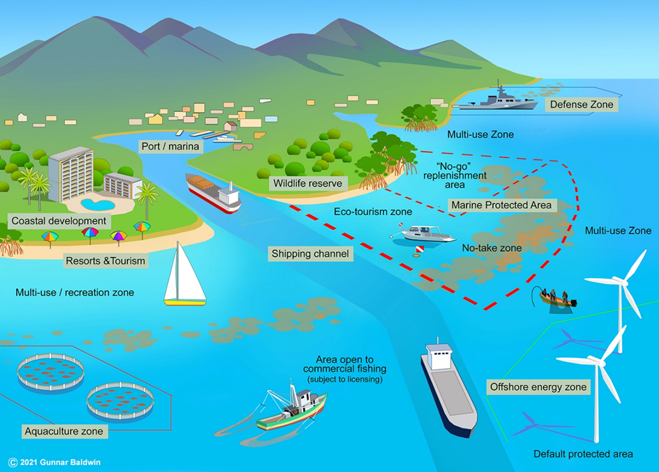
In this context, planning the sea no longer means simply deciding where fishing, energy or conservation can take place. It also means considering what effects those changes will have on ports, beaches, infrastructure and human settlements.
Harmonising sectoral policies
A less visible but decisive aspect is harmonisation with the sectoral policies already in place along the coastline. There are already frameworks such as the Marine Strategies, the Sectoral Territorial Plan for the Coastline (PTS del Litoral), the Coastal Act, the river basin management plans and the management plans for protected areas — each with its own timetable, its own competent authority and its own technical logic. Marine-coastal planning does not replace any of these; it seeks to coordinate them.
The aim is not to merge competences, but to align objectives. Estuary management plans will need to share criteria with marine environmental status indicators and to incorporate the coastal risk projections produced by oceanographic monitoring. In practice, this means creating shared data infrastructures, common criteria and consultation processes rather than ignoring or overlapping them. This coordination work is what allows coastal planning to help maintain and develop marine and terrestrial ecosystems, rather than simply dividing space into zones.
In this vein, NAIDER, together with AZTI and Ihobe, is currently working on an action plan for the climate change adaptation of coastal and littoral habitats of community interest in the Basque Autonomous Community.
Work of this kind requires coordination between areas that have historically operated in isolation. Conservation, water management, spatial planning and the fishing sector share the same coastline. Advancing towards a common objective demands that these areas work from a shared diagnosis of habitat conditions, access to the same climate projections and recognise mutually coherent action priorities. This is where an action plan adds value — not as yet another instrument added to those already in existence, but as a framework that helps different sectors understand each other and work in the same direction.
New technologies and the future of planning
All of this is underpinned by tools that are emerging to change the way we work. The development of Digital Twins — which has been under way for some years — is emerging as a promising tool for better understanding marine-coastal dynamics. In the Basque Country, this is already in progress through the Basque Operational Oceanography Research Infrastructure (Euskoos), led by AZTI. This works with the latest measurement technologies and methodologies, building virtual replicas of the Basque coastline, integrating real observations and advanced modelling connected to European satellites such as Copernicus and EMODnet.
At the same time, in recent years, Artificial Intelligence has ceased to be an auxiliary tool for researchers and technicians, and has begun to be embedded in the workflows of administrations, technology centres and coastal managers. This integration changes something more than productivity — it modifies the very way planning is done, drawing on systems that learn, update themselves and improve with each cycle.
Looking ahead, the potential is greater still. Coastal and marine planning will be able to advance towards environments capable of anticipating events with greater precision and evaluating the effects of multiple pressures on a single space. All of this will lead to better planning of marine-coastal territory, strengthening knowledge and understanding of coastal ecosystems and the relationships between sectoral policies.
Illustration: Esteban Palacios Blanco