We are beginning to prepare for a new way of living alongside climate change — one that demands we strengthen our capacity to respond to meteorological swings and step outside armed with a fan and a water bottle.
Beyond the light-heartedness, the reality is that cold spells and heat waves — such as the one forecast for Sunday, 21 June — can cause fainting, aggravate illness and even prove fatal.
In the Basque Country, the 2026 Heat Plan revolves around three types of alert: yellow, orange and red. A network of climate shelters only works when preparedness is in place before any of these alerts is triggered. Under a yellow warning, information is shared and escalation is prepared. An orange alert activates reference shelters and the monitoring of vulnerable people. Under a red alarm, the network operates as a reinforced public protection device. Activation must not depend on the goodwill of whatever facility happens to be open; it must be agreed, communicated and coordinated in advance.
Local councils also bear responsibility for attending to their residents — by virtue of the territorial reach of public services, by proximity and by local knowledge.
The first step is knowing how to activate and escalate the Heat Plan in your municipality: how to amplify the alerts issued by Euskalmet, how to organise internally and with supra-municipal bodies to activate response protocols, provide cooling spaces and health assistance, while applying measures to reduce heat-absorbing surfaces and increase shaded areas — whether vegetated or not.
Heat, cold and flooding never arrive at a convenient moment. Paradoxically, they tend to strike on a Sunday afternoon in August or on a winter’s night, as though intent on catching us at our most vulnerable.
It is important to undertake a reflective exercise and analyse where and how heat-wave impacts have occurred — in the same way that URA develops statistical flood scenarios — in order to gauge, as best we can, the degree of threat we face.
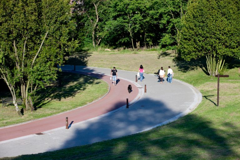
Heatstroke can hit you at the beach — and it frequently does — even with the sea in front of you, a fountain a hundred paces away and a lifeguard to your right: it is precisely the area that receives the most hours of sunlight.
Planning all of this with other local departments — health, emergency services and public safety — is essential in order to orchestrate a coordinated response. Who will open public buildings on an orange-alert Sunday? Who will issue preventive communications? How will we assist vulnerable people? These are questions that technicians and elected officials in every administration must have answered in advance.
Some residents head to the shopping centre during heat waves. Others prefer the beach, the hills or the park with their children; some go to the cinema, the library or the town centre. Wherever the heat finds you, you will need a collective response.
If you feel unwell, ask for a glass of water in a café, seek assistance at a pharmacy or sit for a while in the nearest air-conditioned shop. These won’t replace medical care, but they can play a part in the response protocol if they know how.
Call them micro-shelters, or whatever we like. What matters is bringing businesses, associations and allies into a larger network, including neighbours, and recovering a collective awareness as a form of resilience in the face of the climate emergency we must confront.
How we look at the city: shade, vulnerability and routes
Designing climate shelters requires viewing the city through three simultaneous lenses: where the most vulnerable people live or move around, where spaces with real capacity to receive them are located, and which routes allow people to reach them with the least solar exposure. The network is strongest when it combines buildings, green spaces, water points, shade, pedestrian routes and local community actors.
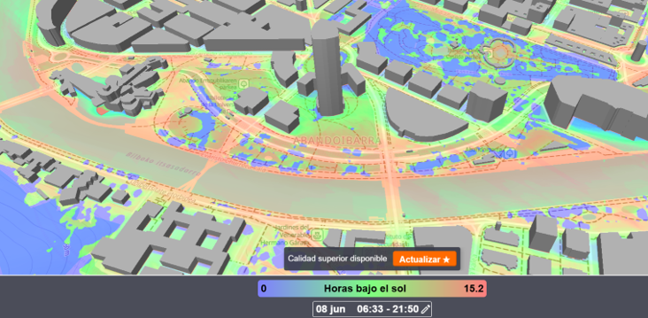
Tools such as ShadeMap can help to visualise urban areas with greater solar exposure and inform decisions on shade provision, water points, signage, seating, comfortable routes and the prioritisation of particularly exposed environments.
A climate shelter is not improvised when an alert arrives; it is built collectively so that, when the heat bears down, the city knows how to take better care of its people.
Fuentes y referencias
- Basque Country Climate Shelter Network — Ihobe
- Basque Country Climate Shelter Network Guide — Ihobe
- Climate shelters in Vitoria-Gasteiz — Vitoria-Gasteiz City Council
- Vitoria-Gasteiz Heat Plan — Vitoria-Gasteiz City Council
- Basque Country Heat Plan 2026 — Basque Government
Methodological note: this text draws on official and municipal references covering climate shelter networks, heat planning and urban analysis tools. The mention of ShadeMap is indicative and does not replace microclimatic measurement, health criteria or local technical analysis.
What NAIDER can contribute
NAIDER can support public administrations in the conception, design and implementation of climate shelter networks: defining criteria, identifying spaces, territorial analysis of vulnerability and sun exposure, operational mapping, micro-shelter activation, communication materials and post-season evaluation of the network.
Photo: Sudeep deep